What Is GeoSlice?
GeoSlice is a free daily geography puzzle that challenges you to divide real-world locations into regions containing approximately equal numbers of people. Instead of guessing countries, identifying flags, or locating cities, you draw lines directly across an interactive map and try to balance the population on each side.
The central question is surprisingly difficult: Where would you draw a line to put exactly half the population on either side?
A geographically equal division is rarely a population-equal division. A small metropolitan area might contain more residents than a vast surrounding countryside. GeoSlice turns that imbalance into an interactive puzzle about settlement patterns, cities, geography, and spatial reasoning.
Each daily mode contains three rounds featuring three different real-world locations. Maps can cover relatively small areas within a country or extend across substantial portions of a continent. The daily locations span at least two continents, providing variety in the geography you encounter.
GeoSlice was created by independent developer Tom, also known as GeoTom, who previously developed the geography game Flagpie.
GeoSlice Rules and Game Modes
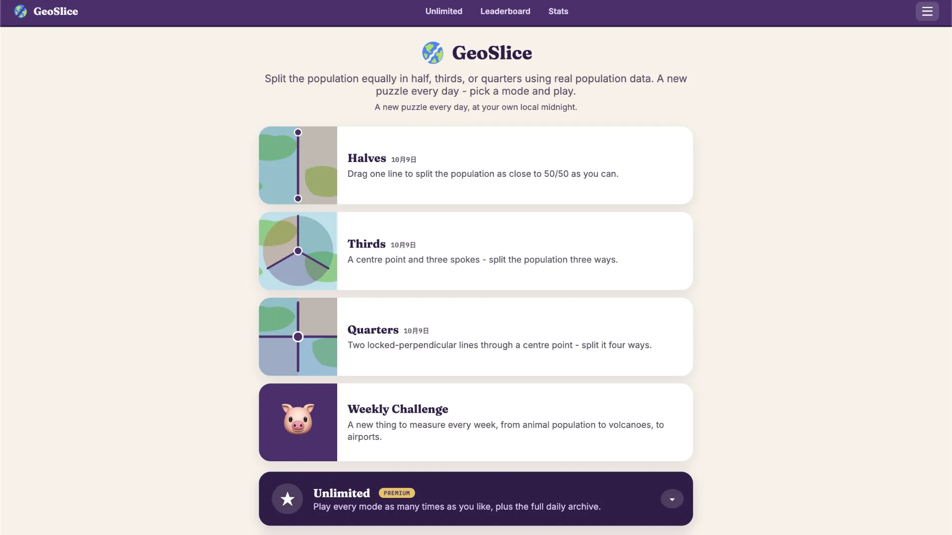
GeoSlice offers three main daily puzzle modes. All three are free to play, and each presents a different way of dividing a region by population rather than by land area.
Halves: Split the Population 50/50
Halves is the simplest mode to understand. You control a single straight dividing line and attempt to place half the region's population on each side.
- Target: 50% of the population on each side.
- Controls: Drag and adjust one dividing line across the map.
- Challenge: Find the population balance point, which may be far from the geographical center.
Example: Imagine a map containing a densely populated city in the east and a large rural region in the west. Drawing a line through the geographical center might leave 80% of residents on one side and 20% on the other. A better split could require moving the line closer to the city, producing something like 49% versus 51%.
The goal is to balance people, not square kilometers.
Thirds: Divide the Population Into Three Equal Parts
Thirds increases the difficulty by introducing three dividing spokes connected to a shared center point.
- Target: Approximately 33.3% of the population in each section.
- Controls: Adjust the central point and the three spokes.
- Challenge: Balance three population groups simultaneously.
You may need to position the center away from the middle of the map to accommodate a major city or a cluster of smaller settlements. A visually symmetrical arrangement does not necessarily create three equally populated regions.
Quarters: Create Four Balanced Regions
Quarters challenges you to divide the population into four sections using two intersecting lines locked at right angles.
- Target: Approximately 25% of the population in each quadrant.
- Controls: Adjust the shared center and orientation of the perpendicular lines.
- Challenge: Distribute the population evenly across four connected map sections.
Because the lines must remain perpendicular, you cannot adjust each quadrant independently. The position and rotation of the entire arrangement matter.
For example, a region with several major cities concentrated along one coastline could require an off-center intersection to prevent one quadrant from containing most of the population.
How to Play GeoSlice
GeoSlice is played directly in a web browser, and the daily challenges do not require an account or installation.
- Open GeoSlice and choose a mode. Visit the official website and select Halves, Thirds, or Quarters. Halves is a good starting point for new players because it uses only one dividing line.
- Study the location on the map. Identify major cities, coastal settlements, rural regions, and other clues about where people might live. Remember that population density matters more than the visible size of the land.
- Position your dividing lines. Drag the available line or handles to create your proposed population split. In Thirds and Quarters, adjust the shared center and line orientations to balance multiple regions.
- Lock in your split. When you are satisfied with your arrangement, select the 'Lock in split' control. The game evaluates your division using its underlying population estimates and awards a score of up to 100 points for the round. A green dashed line shows an adjustment that would have improved your result.
- Complete the remaining locations. Continue through all three rounds in your chosen mode, review your results, and compare your performance. You can also try the other daily modes for different challenges.
A new daily puzzle becomes available at midnight in your local time zone.
How Does GeoSlice Scoring Work?
GeoSlice measures how closely your drawn regions match the target population proportions. Each round is scored out of 100 points, with more balanced divisions receiving higher scores.
In Halves, a result close to 50% and 50% earns a stronger score than a noticeably uneven division. Thirds and Quarters apply the same principle to three and four population groups.
After submitting a split, the game provides feedback, including a green dashed line representing a better adjustment toward an even division. This makes the results useful for learning how population is distributed across the location.
The challenge is not to divide the map into equally sized shapes. It is to divide the estimated population as evenly as possible.
Where Does the Population Data Come From?
GeoSlice uses gridded population estimates from WorldPop, a research initiative that models where people live using sources such as census information, surveys, satellite imagery, settlement patterns, and machine-learning methods.
Unlike a simple database of city populations, gridded data also accounts for populations outside named cities and towns. Rural settlements can therefore influence the correct division.
These figures are modeled estimates, not exact population counts. Results may be less precise in places with outdated census information, rapid population changes, or limited reliable data.
GeoSlice Strategy Tips
1. Identify Population Centers Before Drawing
Locate the largest cities and urban corridors first. A small metropolitan area can outweigh a much larger rural region. Your dividing line should reflect that concentration rather than the map's visual center.
2. Think About Population Density, Not Land Area
Equal-sized map sections can contain dramatically different populations. Mountain ranges, deserts, forests, and remote countryside often have far fewer residents than urban or agricultural areas.
3. Consider Coastal and River Settlements
Many regions have substantial populations concentrated around coastlines, river valleys, transport corridors, and major cities. Use these patterns as clues when estimating where the population lies.
4. Move the Center Strategically in Thirds and Quarters
For multi-section puzzles, concentrate on the location of the shared center. If one section contains a particularly large city, an off-center arrangement may distribute the remaining population more effectively.
5. Learn From the Post-Round Feedback
Pay attention to the green dashed adjustment shown after submitting. Compare it with your original line to understand whether you underestimated or overestimated the population in a particular area.
6. Practice Different Geographic Scales
A puzzle covering several countries requires different assumptions from one focused on a single metropolitan region. Try to recognize when population is concentrated in a few cities and when it is distributed among numerous smaller settlements.
Is GeoSlice Free to Play?
Yes. All three daily modes—Halves, Thirds, and Quarters—are free to play without an account. GeoSlice works in desktop and mobile browsers, and the official website does not require downloading a separate app.
Guest players can keep local statistics and streaks in their browsers. Creating a free account and setting a username enables participation in the public leaderboard and daily XP system.
Optional GeoSlice Premium features include:
- Unlimited Play: Generate additional random-location puzzles without waiting for the next daily challenge.
- Daily Archive: Replay challenges from previous dates.
- Country Mode: Choose a specific country or select a random country for population-splitting challenges.
- World Regions: Explore continents and smaller geographical regions.
- States and Provinces: Play specialized geographical challenges involving supported administrative regions.
The regular daily geography puzzles remain available without paying.
GeoSlice also offers a separate Weekly Challenge featuring changing measurement themes, including topics such as animal populations, volcanoes, and airports.
Who Should Play GeoSlice?
GeoSlice is particularly appealing to players who enjoy geography puzzles but want something different from conventional country-guessing games.
It is a good choice for:
- Geography enthusiasts interested in population patterns and human geography.
- Fans of daily browser puzzles who enjoy short, repeatable challenges.
- Players who like interactive maps and spatial reasoning.
- Anyone curious about how cities, regions, and rural populations are distributed.
- Players who enjoy comparing their results and improving through feedback.
Unlike games focused on memorizing capitals or recognizing flags, GeoSlice rewards geographical intuition and a practical understanding of where people live.
Final Thoughts
GeoSlice transforms a simple concept—dividing a map—into a surprisingly challenging daily geography game. Its distinctive mechanic comes from balancing real-world population estimates rather than land area, revealing how unevenly people are distributed across the planet.
With three free daily modes, different locations, interactive map controls, and immediate scoring feedback, GeoSlice offers an accessible way to explore human geography through play.
Ready to test your geographical intuition? Visit GeoSlice, start with Halves, and see how close you can get to a perfect 50/50 population split.