SatZoom
SatZoom
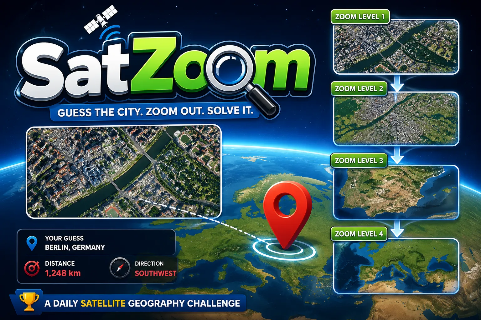
SatZoom is a daily satellite geography game where you guess a mystery city from zoomed-in satellite imagery. Each wrong guess zooms the image out and gives distance and direction clues.
What is SatZoom?
SatZoom is a daily geography guessing game where you identify a mystery city from satellite imagery. The puzzle starts with a close-up satellite view, and each incorrect guess zooms out to reveal more of the surrounding area.
It is fun because it turns city recognition into a visual deduction challenge. Urban grids, rivers, coastlines, parks, ports, airports, mountain edges, and road patterns all become clues that help you work toward the correct city.
SatZoom Game Rules
- Each puzzle hides one mystery city.
- The game begins with a zoomed-in satellite image of that city.
- You type a city name as your guess.
- You have a limited number of attempts, commonly 6 tries.
- After an incorrect guess, the image zooms out and reveals more context.
- The game may also show distance and direction hints from your guess to the correct city.
- You can use satellite clues such as urban layout, water, terrain, roads, and landmarks.
- The goal is to guess the correct city in as few tries as possible.
How To Play SatZoom?
-
Player Action: Study the first zoomed-in satellite image.
Game Response: SatZoom shows a close-up view of part of a city.
What You Learn: Texture, street pattern, building density, green space, and water nearby can suggest a type of city. -
Player Action: Enter a city guess.
Game Response: The game checks your answer against the hidden city.
What You Learn: A correct guess solves the puzzle; a wrong guess gives you more information. -
Player Action: Read the distance and direction feedback.
Game Response: SatZoom indicates how far and in what direction the real city is from your guess.
What You Learn: You can shift your next guess across the map instead of guessing randomly. -
Player Action: Use the next zoomed-out image.
Game Response: More of the city and surrounding geography becomes visible.
What You Learn: Rivers, coastlines, mountains, airports, bridges, and city shape can narrow the answer. -
Player Action: Submit a refined city guess before attempts run out.
Game Response: A correct answer completes the daily challenge.
What You Learn: The city can be solved by combining satellite patterns with distance and direction clues.
Strategy & Tips
- Start with broad visual clues: coast, river, desert, mountains, grid streets, or dense downtown texture.
- Use road patterns carefully. North American grids, European historic cores, and Asian megacity layouts can look very different.
- Water is often the strongest clue: bays, harbors, river bends, lakes, and deltas can identify a city quickly.
- If your first guess is wrong, treat the distance and direction as a map correction, not just a score penalty.
- Look for airports, ports, bridges, stadiums, parks, or unusual landmarks as the image zooms out.
- Avoid guessing too narrowly from one small crop; wait for more context if the satellite image is ambiguous.
- Practice country or region modes to learn recurring city shapes before playing the global daily puzzle.
SatZoom FAQ
Is SatZoom free to play?
SatZoom is available as a web-based satellite geography game. Check the official SatPixel page for the current play options.
What kind of game is SatZoom?
SatZoom is a daily city guessing game that uses satellite imagery, progressive zoom levels, and distance or direction hints.
How do you play SatZoom?
You study a satellite image, guess the city, use zoomed-out reveals and location feedback after wrong guesses, and try to solve the mystery city within the attempt limit.
Is SatZoom like Wordle?
SatZoom is Wordle-like because it has daily guessing and limited attempts, but the clues are based on satellite geography instead of letters.
Is SatZoom good for beginners?
Yes. Beginners can use zoom-out reveals and distance hints to learn, while experienced geography players can try to solve from the earliest image.
Final Take
SatZoom is a great daily puzzle for players who enjoy geography games, satellite maps, city recognition, and visual deduction. Try it if you like using real-world map clues to identify cities from above.