Snaptrip
Snaptrip
Snaptrip is a photo-based geography guessing game where you inspect real travel snaps and drop a pin on the map. The closer your guess lands to the real location, the better your score.
What is Snaptrip?
Snaptrip turns travel photos into a geography showdown. You are shown a real-world image — maybe a coastline, a city street, a mountain lake, a market, or a quiet village corner — and your mission is to figure out where on Earth it was taken.
The twist is that the photo is both beautiful and dangerous. Every detail can help: road signs, architecture, weather, plants, mountains, shop fronts, license plates, street layouts, and even the color of the light. Snaptrip feels like a travel game, a detective puzzle, and a map challenge all at once.
Snaptrip Game Rules (The Catch / The Trap)
The core loop is simple:
Photo → Clues → Map Pin → Distance → Score
You inspect a photo, place a pin on the map, and submit your guess. The game then reveals how close you were to the real location.
Key rules:
- You MUST use the photo as your main clue source.
- You place a guess pin on the world map.
- You can drag or adjust your pin before submitting.
- Closer guesses earn better results and higher scores.
- Daily play gives everyone the same challenge, so scores can be compared.
- In multi-photo rounds, each photo is a new chance to recover, climb, or collapse.
The trap is that Snaptrip does not always reward the obvious first impression. A beach could be Mediterranean, Caribbean, Australian, or somewhere completely unexpected. A European-looking street might be in Europe — or it might be a colonial district halfway across the world. The image is the battlefield, and tiny clues are your weapons.
How To Play Snaptrip?
-
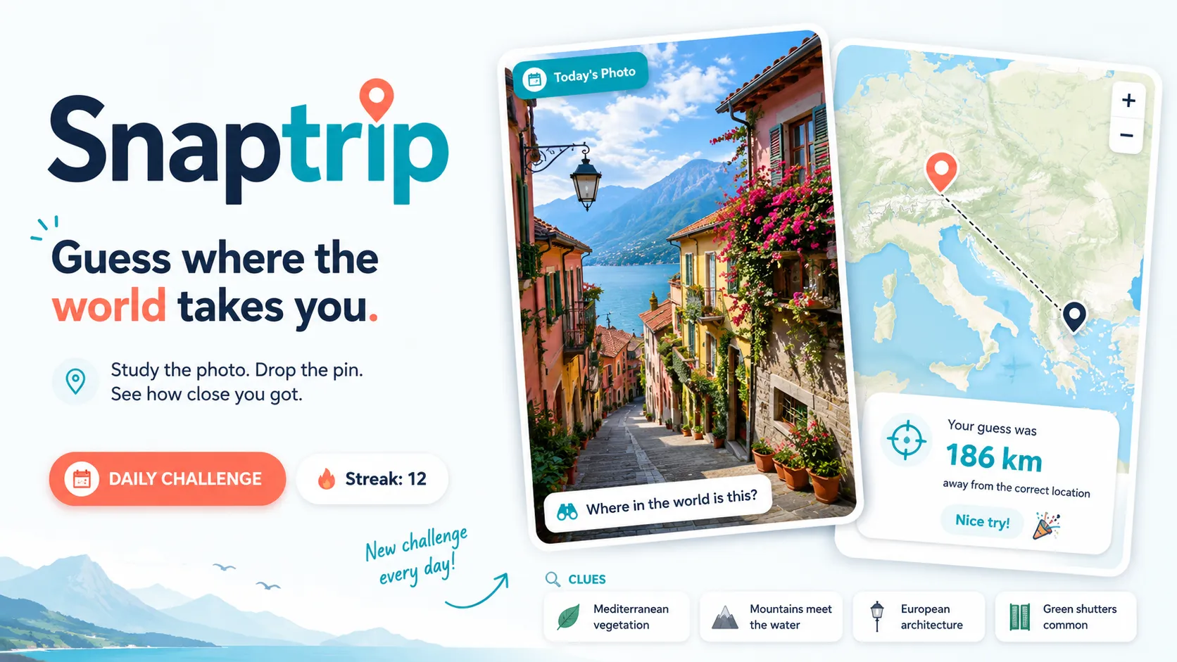
Inspect the photo
Photo Shows: a narrow street, tram tracks, tiled sidewalks, and shop signs.
What You Learn: The language, street design, and architecture may point toward a specific city or region. -
Open the map and place a pin
Player Action: Click or tap the map near your best guess.
Map State:📍 Your Guess: Lisbon, Portugal
Next Constraint: Adjust the pin if the clues suggest a more precise neighborhood or country. -
Submit your guess
Game Response:Distance: 186 km
What This Means: You were in the right region, but not close enough for a perfect score. -
Move to the next photo
Photo Shows: mountains, a lake, pine trees, and a road sign.
Player Thinks: “Alps? Canada? Scandinavia?”
Goal: Use terrain, signs, and landscape clues to narrow the map before placing the next pin. -
Chase the best total score
Round Result: each photo adds pressure.
Victory Feeling: You did not just guess a place — you read the world correctly.
Snaptrip Strategy & Tips
Start broad, then zoom in. First identify the continent or climate zone, then narrow toward country, city, and exact area.
Look for language clues immediately. Signs, menus, road markings, warning labels, and shop names often cut the search area dramatically.
Do not ignore the background. Mountains, coastlines, vegetation, road quality, utility poles, traffic signs, and building materials can reveal more than the main subject of the photo.
When two places feel possible, use the map like a risk meter. A central guess between likely areas can save your score, while a bold exact-city guess can win big if your detective instincts are right.