What Is BlindGlobe?
BlindGlobe is a free daily geography guessing game that tests how accurately you can locate places on Earth without the familiar labels, political boundaries, and map markers found on conventional maps.
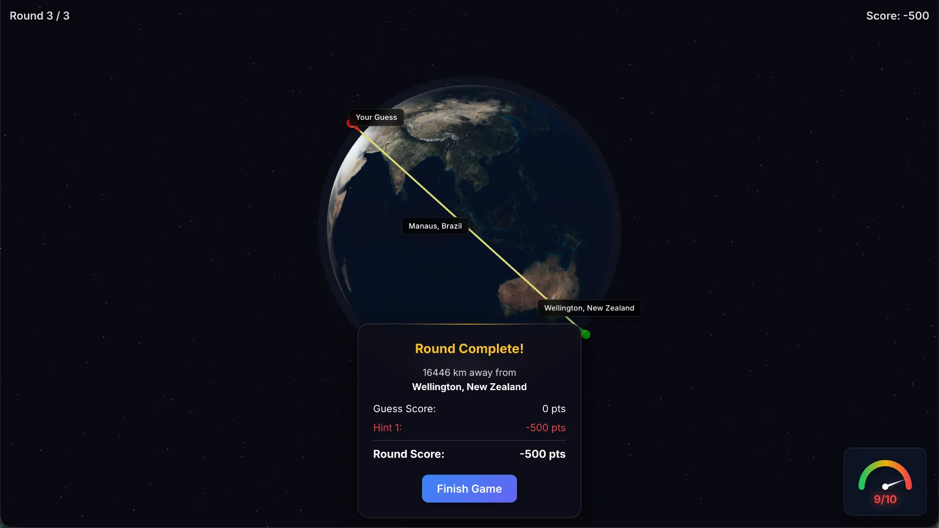
Created by independent developer Sam Steingard, BlindGlobe presents a rotating 3D globe showing the shapes of Earth's continents and oceans. Unlike most geography games, the globe does not initially display country borders, country names, or city labels.
Instead, you receive the name of a target city and a single reference city marked in green. Your challenge is to use that reference point, your knowledge of world geography, and the shapes of the surrounding landmasses to work out where the target city belongs.
For example, if the reference city is Paris and the target is Madrid, you need to mentally position Madrid southwest of Paris, within the Iberian Peninsula, before placing your marker.
The closer your chosen location is to the real city, the more points you earn. Optional hints can make the challenge easier, but they come with score penalties.
BlindGlobe provides a fresh daily challenge featuring multiple locations. It is related to MapTap, another geography game hosted under the Terpscoops domain, but removes many of the visual aids players normally rely on.
BlindGlobe Game Rules
The main objective is to identify the geographic position of a named city on a nearly blank 3D globe.
The basic rules are:
- Find the named location: The game provides the name of the city you need to locate.
- Use one reference city: A green marker shows a known city that acts as your geographic starting point.
- No initial political borders: The globe does not normally show country boundaries or place labels.
- Rotate the globe: Drag the globe to explore different continents and regions.
- Zoom for accuracy: Adjust the zoom level to position your marker more precisely.
- Place a marker: Click or tap where you believe the target city is located.
- Confirm your choice: You can adjust the marker before committing to your placement.
- Score by distance: Your result depends on how far your guess is from the actual location.
- Optional hints: You can reveal the target country or display country outlines, but doing so costs points.
- Daily challenges: New geography challenges are provided on a daily basis.
Unlike games where you must identify a mystery country from a series of guesses, BlindGlobe tells you which place to find. The difficult part is locating it accurately without a labeled map.
How to Play BlindGlobe
- Open the daily game: Visit BlindGlobe in your browser and start the challenge. Read the target city and identify the green reference-city marker on the globe.
- Estimate the target's position: Before touching the globe, think about where the target sits relative to the reference city. Consider the continent, hemisphere, compass direction, approximate distance, and nearby coastlines.
- Rotate and zoom: Drag the 3D globe until the likely target region faces you. Zoom in when you are confident about the general area.
- Place and confirm your marker: Click or tap the globe to mark your estimated location. Reposition the marker if necessary, then confirm your answer. Optional hints are available if you need more information.
- Review your accuracy: Compare your selected position with the actual target location and examine your score. Continue through the remaining daily locations and see how accurately you can navigate the world.
The controls are simple, but accurately placing a city without borders or labels requires strong spatial memory and geographic intuition.
Example: How a BlindGlobe Round Works
Consider a hypothetical round with the following information:
Reference city: Paris, France
Target city: Madrid, Spain
The globe initially shows a green marker for Paris and the unlabeled shapes of Europe's landmasses.
Your task is to locate Madrid without the usual country names or city markers.
A useful reasoning process would be:
- Identify the position of Paris in Western Europe.
- Recall that Madrid is southwest of Paris.
- Locate the Iberian Peninsula using the Atlantic coastline and Mediterranean Sea.
- Estimate Madrid's position in the interior of central Spain.
- Place your marker and submit the answer.
A simplified directional sketch looks like this:
               NORTH
                 ↑

             PARIS ●

               ↙

       ● MADRID

WEST ←               → EAST
                 ↓
               SOUTH
This diagram is only a conceptual illustration of the relative direction. It does not reproduce the game's interface or an actual daily puzzle.
The key insight is that BlindGlobe asks you to reconstruct a mental map rather than identify a place from visible labels.
Understanding the Blank Globe
The lack of labels is BlindGlobe's defining mechanic.
No Country Names
You cannot simply search for the country containing the target city and then click a labeled location.
Instead, you must remember where countries and regions lie relative to recognizable physical landmarks.
No Political Borders by Default
Country boundaries are normally absent from the globe, making it harder to distinguish neighboring nations.
For example, Central Europe contains many countries whose boundaries are not obvious from the surrounding coastline alone.
One optional hint reveals country outlines, but using it comes with a substantial scoring penalty.
Landmasses and Coastlines Remain Visible
BlindGlobe is not a completely featureless sphere. The broad shapes of continents, coastlines, and oceans remain visible.
These geographic shapes become your primary navigation tools.
Large features such as the Arabian Peninsula, Mediterranean Sea, British Isles, Japanese archipelago, and southern tip of Africa provide useful reference points.
One Green Reference City
The reference city acts as an anchor for your estimates.
If you recognize the approximate direction and distance between the reference and target, you can often narrow the possible placement considerably.
However, the green marker does not automatically reveal the political boundaries or exact location of the target city.
BlindGlobe Scoring System
BlindGlobe rewards accuracy rather than speed or the number of words guessed.
The distance between your marker and the real location determines your performance.
According to the game's documented tutorial, a guess within 50 kilometers of the target earns 5,000 points for that placement.
The further your marker is from the real location, the lower your proximity-based score becomes.
| Result | Scoring Interpretation |
|---|---|
| Within 50 km | 5,000 points according to the tutorial |
| Outside 50 km | Reduced score based on distance |
| Reveal country | 500-point hint cost |
| Show country outlines | 2,000-point hint cost |
The exact score reduction for every possible distance is not established by the available gameplay documentation, so the table does not assume an unverified formula.
The game also displays statistics such as games played, high score, and average score.
The scoring creates a clear incentive to estimate the target's location as precisely as possible while minimizing hint usage.
BlindGlobe Hints Explained
BlindGlobe provides optional assistance for players who become stuck.
Reveal Country — 500 Points
This hint identifies the country containing the target location.
Knowing the country can dramatically reduce uncertainty, especially when the target city is unfamiliar.
However, identifying the correct country is only part of the challenge. You must still decide where the city sits within that country.
Show Country Outlines — 2,000 Points
This hint reveals political boundaries on the globe.
It is particularly useful in regions where coastlines alone provide limited guidance, such as Central Asia, inland Africa, and Central Europe.
Because the point cost is much higher, it is best reserved for situations where the outlines would significantly improve the accuracy of your placement.
Should You Use Hints?
That depends on your goal.
If you want to maximize your score, try solving without assistance first.
If you are still learning world geography, using the country or border hints can help you understand why your initial mental estimate was incorrect.
BlindGlobe Strategy and Tips
1. Start With the Reference City
Before rotating the globe, mentally locate the green reference city and consider where the target lies relative to it.
A simple directional estimate can eliminate a large portion of the globe.
For example, if the target is north and east of the reference point, there is little reason to explore areas to the south and west unless your initial geographic assumptions are uncertain.
2. Think in Hemispheres
Begin with a broad geographic estimate.
Is the target in the Northern or Southern Hemisphere? Is it east or west of the reference city? Is it near the equator or considerably farther north or south?
These large-scale distinctions are often more useful initially than trying to remember exact coordinates.
3. Use Coastlines as Landmarks
Coastlines are among the few visible geographic clues available without hints.
Look for distinctive shapes such as Italy's peninsula, the Horn of Africa, the Korean Peninsula, and the outline of Australia.
Recognizing the surrounding physical geography can help you estimate where an inland city should be located.
4. Estimate Latitude Before Longitude
Latitude describes how far north or south a place is located.
Estimating the correct latitude band can prevent major errors before you begin adjusting the east-west position.
For example, London and Moscow occupy broadly similar northern latitude bands despite being far apart longitudinally.
Do not assume that cities with similar climates or cultural connections are necessarily located at similar latitudes.
5. Judge Relative Distance
Once you know the approximate direction from the reference city, consider how far away the target should be.
A city in a neighboring country may be only a few hundred kilometers away, while a destination on another continent could be thousands of kilometers distant.
Distance estimation becomes increasingly important when attempting high scores without hints.
6. Rotate the Globe Before Zooming In
It is easy to misjudge a location when a landmass is near the edge of the visible sphere.
Rotate the globe until the region you want to inspect is close to the center of your view.
Then zoom in to refine your marker placement.
This can help reduce the visual distortion caused by viewing a curved surface at an angle.
7. Take Extra Care With Inland Cities
Coastal cities often benefit from nearby recognizable shorelines.
Inland cities can be considerably harder because no obvious geographic boundary identifies their position.
When locating an inland city, think about nearby rivers, mountains, regional capitals, and major population centers, even if these features are not labeled on the globe.
8. Avoid Unnecessary Hints
Hints deduct points, so revealing extra information is not automatically the best move.
If you already know the target country and approximate region, spending 500 points to reveal that country provides little additional benefit.
Save hints for unfamiliar locations where the information would materially improve your estimate.
9. Practice With Mental Maps
BlindGlobe is a useful exercise in active geographic recall.
Rather than simply memorizing country names, practice remembering where major cities sit relative to neighboring regions, coastlines, and one another.
Repeated exposure to geographic relationships can help build the spatial intuition needed for more accurate placements.
BlindGlobe vs MapTap, Globle, and GeoGuessr
BlindGlobe shares elements with several popular geography games, but its core challenge is different.
| Game | Main Objective | Available Geographic Clues |
|---|---|---|
| BlindGlobe | Place a named city on an unlabeled globe | One reference city, landmass shapes, optional hints |
| MapTap | Pinpoint named cities on a 3D globe | Interactive geographic map |
| Globle | Identify a hidden country | Country outlines and proximity colors |
| Worldle | Identify a country from its silhouette | Shape, distance, and direction feedback |
| GeoGuessr | Identify a location from street-level imagery | Roads, signs, scenery, architecture, and other visual details |
BlindGlobe vs MapTap
MapTap and BlindGlobe share a globe-based placement mechanic and are associated with the same game-hosting domain.
MapTap asks players to pinpoint named cities using a more conventional 3D globe experience.
BlindGlobe removes the usual labels and borders, leaving only a reference city and the underlying landmasses to guide the player's judgment.
This makes BlindGlobe a more demanding variation for players who already enjoy MapTap.
BlindGlobe vs Globle
Globle asks players to discover a hidden country by guessing country names and using color-based proximity feedback.
BlindGlobe reverses that idea. You are told the target location and must supply the coordinates through a physical marker placement.
The challenge is not identifying the name but remembering the geographic position.
BlindGlobe vs GeoGuessr
GeoGuessr challenges players to infer a location from visual evidence such as road signs, landscape, buildings, and vegetation.
BlindGlobe does not provide street-level imagery. Its core test is the player's existing geographic knowledge and spatial reasoning.
Is BlindGlobe Free to Play?
Yes. BlindGlobe is available as a free browser-based geography game.
Players can open the website and use its interactive 3D globe without installing a separate application.
The game supports desktop and mobile interactions, including touch-based globe rotation and zooming.
It was developed using browser-based 3D rendering technology, allowing the globe to respond interactively to player movements.
Frequently Asked Questions
What is BlindGlobe?
BlindGlobe is a daily geography placement game where players locate named cities on a blank 3D globe using a single reference city and their knowledge of world geography.
How do you play BlindGlobe?
Read the target city, examine the green reference marker, rotate the globe, and place a marker where you believe the city is located. Confirm your answer to receive a distance-based score.
Is BlindGlobe free?
Yes. BlindGlobe is free to play in a web browser.
Does BlindGlobe show country borders?
Not by default. The globe normally lacks political boundaries and city labels. Country outlines are available through an optional hint that costs points.
What does the green marker mean?
The green marker identifies a reference city. Use it to estimate the target location's direction and distance.
How are BlindGlobe points calculated?
The game awards points based on how accurately your marker matches the real target location. The documented tutorial states that a placement within 50 kilometers earns 5,000 points.
How much do BlindGlobe hints cost?
Revealing the target country costs 500 points, while showing country outlines costs 2,000 points, according to the documented gameplay instructions.
Can you move your marker before submitting?
Yes. The documented controls allow players to place and adjust their marker before confirming the location.
Does BlindGlobe have a new challenge every day?
Yes. BlindGlobe offers daily geography challenges with multiple target locations.
Is BlindGlobe the same as MapTap?
No. Both games involve placing cities on a 3D globe, but BlindGlobe makes the task harder by removing normal map labels and political boundaries and providing one reference city.
Can you play BlindGlobe on mobile?
Yes. The creator describes mobile touch controls, including globe rotation and zooming.
Who created BlindGlobe?
BlindGlobe was created by Sam Steingard, an independent developer who describes the game in his project case study.
Do you need to know exact coordinates?
No. The game does not require you to type latitude and longitude coordinates. Instead, you place a marker directly on the globe. However, knowing approximate geographic positions can help improve your score.
Who Should Play BlindGlobe?
BlindGlobe is particularly appealing to players who enjoy geography, world maps, location guessing, and spatial reasoning challenges.
It is especially suitable for fans of MapTap who want a harder variation with fewer visual clues.
Players who already know many country capitals and major cities may enjoy testing how accurately they can locate those places without familiar political boundaries.
The game can also be useful for geography learners who want to develop a stronger mental picture of the world rather than relying on labeled maps.
Unlike rapid-fire trivia games, BlindGlobe rewards careful observation and thoughtful positioning.
Conclusion
BlindGlobe offers a distinctive daily geography challenge by removing most of the familiar information found on traditional maps.
With an unlabeled 3D globe, one reference city, distance-based scoring, and optional hints, it tests how accurately players understand the positions of real places on Earth.
The best approach is to establish the target's broad region, estimate its direction and distance from the reference city, and use coastlines to refine the final placement before confirming.
How accurate is your mental world map? Play BlindGlobe for free and see how close you can get to today's cities without relying on country borders or map labels.
For additional information, see the creator's BlindGlobe project page and the gameplay overview on Nextdle.